1. INTRODUCTION
Geomorphometry is the measurement and mathematical configuration of the earth’s surface, dimensions, and landforms. (Burrough & McDonnell, 1998 Chorley, Schumm, & Sugden, 1984; Clarke, 1966; Evans, 1984; Horton, 1945; Merritts & Vincent, 1989; Oguchi, 1997; Strahler, 1952; Hengl 2008).
The morphometry of the drainage basin is maintained through geological and geomorphological processes over time, as indicated by various morphometric studies. (Horton, 1945; Strahler, 1964; Shreve, 1969; Chorley 1984).
Estimating morphometric parameters requires the measurement of linear, areal, relief, and gradient parameters of the drainage network to assess the hydrological system’s characteristics in the basin area (Horton, 1932).
Quantitative basin analysis is an essential aspect of basin characterization (Strahler, 1964). The application of quantitative techniques in the morphometric analysis of basins was started (Horton, Strahler, etc.) from topographic maps using manual methods. Outdated manual methods for determining morphometric terrain characteristics have been replaced by the Digital Elevation Model (DEM) and GIS development.
DEM is a digital statistical model of the terrain with a series of known x, y, and z coordinates within an arbitrarily selected system (Miller and Laflamme., 1958).
The process of creating a digital terrain model begins by selecting one of the methods of elevation data collection, sampling points with specific accuracy, density, and distribution, followed by spatial interpolation of collected data in software programs, which provides continuous quantitative terrain data (Hengl et al., 2003; Siljeg., 2013; Wilson and Gallant, 2000).
Open to all Digital Elevation Models (DEM) ASTER, SRTM, AW3D30, EU-DEM medium resolutions have improved geomorphometric analyzes in underdeveloped and developing countries. The last decade has been characterized by many geoportals from which free DEM data of medium resolution can be downloaded.
Morphometric analysis of the drainage basin based on DEM data using GIS was performed by many researchers and scientists for different regions. This combination proved to be a useful tool for generating detailed and updated quantitative data to characterize the morphometric parameters of the drainage basin. (Singh et al., 2014; Hlaing et al., 2008; Javed et al., 2009; Singh et al., 2014; Pankaj and Kumar, 2009; Resmi et al., 2019; Pareta, Kuldeep & Pareta, Upasana. , 2011; Saha et al., 2017).
2. STUDY AREA
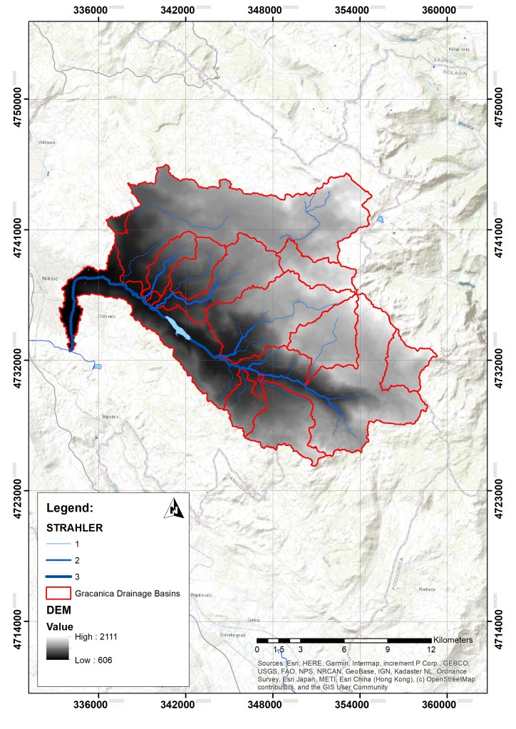
The drainage basin of the river Gracanica covers an area of 311 km2. It occupies the area of central Montenegro between 42˚ 39 ′ and 42˚ 50 ′ north latitude and 19˚ 12′ and 19˚ 19′ east longitude, as part of the complex hydrographic network of the Skadar Basin, which belongs to the Adriatic Sea Basin (Figure 1). The drainage basin includes the southern part of the Niksicko polje, the northern, northeastern and eastern slopes of the mountains Zirovnica, Prekornica, Miljevac, the southern, southwestern and western slopes of the mountains Maganik, Zurim, and Vojnik.

It is believed that the flow of the river Gracanica was determined by a tectonic fissure, which was of crucial importance in the formation. The terrain is represented by alluvial sediments, limestone, and eruptive sites. Due to the different composition of the terrain, the hydrological surface and underground phenomena in the basin of the river Gracanica are also different.
The length of the main course of the river Gracanica is about 29.5 km, of which 21.5 km to the entrance to Niksicko polje. Until entering Niksicko polje, the direction of the river flow is southeast-northwest, and in the plain of the field, after a long meandering, the river stabilized its flow in the north-south direction and flowed into the river Zeta in the southern part of Niksicko polje. The main course of the river Gracanica springs in three tributaries in the form of a broken spring at about 1186 m above sea level. At Jerina’s town, at an altitude of 903 m above sea level. It connects with the stream Susjed (Smrdan), which erupts at the foot of Prekornica at an altitude of 972 m above sea level—forming a constant flow of Gracanica. In the drainage basin of Gracanica, we have a large number of torrents, especially during periods of heavy rains. The river Gracanica, from which the artificial Liverovic Lake is created, has tributaries on the right side: Usovina, Slatisnjak, Macak, Zljebina and Revina, and on the left side are tributaries: Bukovik, Gojusa, and Jablanica. During heavy rains, occasional tributaries are also significant: Mijatov potok, Radulovica potok, Babina rupa and Botanac.
The study area is characterized by transitional features between the Mediterranean and continental climates. The relief and altitude strongly influence the climate. The average annual air temperature is 10.9 °C; in January, it is 1.3 ° C, in July 21.1 ° C. Temperatures are highest in July and August and lowest in January and February. The average annual rainfall is 1,993 mm. The maximum amount of precipitation is in November and December, while the minimum is in July and August. Snow falls on average for 19 days and lasts 29 days a year in Niksicko polje, while in the mountains and surrounding areas, it lasts up to six months. The average relative humidity is 68.6%. The dominant winds are north and south.
Gracanica has a rain-snow regime. The highest water level is in the spring, due to heavy spring rains and intense snowmelt. The lowest water level is in the summer months when there are little precipitation and high temperatures. The lowest flows are in the period July-September, and the highest in November and December.
3. MATERIALS AND METHODS
3.1. Data
The paper uses the EU-DEM model of the European Environment Agency, which covers the European Union’s territory of 32 member states and six collaborating countries (Bashfield and Keim., 2011).
The model is of medium quality, with a spatial resolution of 25 m. It has similar characteristics to the ASTER and SRTM model. EU-DEM validation due to vertical properties and radio usage with SRTM DEM and ASTER GDEM data shows that this model has higher vertical accuracy and improved hydrological parameters (Bashfelid and Keim., 2011; Mouratidis and Ampatzidis., 2019).
The accuracy of EU-DEM was evaluated using various reference values such as trigonometric points, LIDAR data, and NEXTmap data. Therefore, the approximate value of the square error for EU-DEM’s vertical accuracy is about 7m (Bashfelid and Keim., 2011; Mouratidis and Ampatzidis 2019; Josa et al., 2014). Data were downloaded for the geoportal (https://land.copernicus.eu/imagery-in-situ/eu-dem) within the COPERNICUS program.
3.2. Methods
Source: http://webhelp.esri.com/arcgisdesktop/9.3/printBooks_topics.cfm?pid=6050
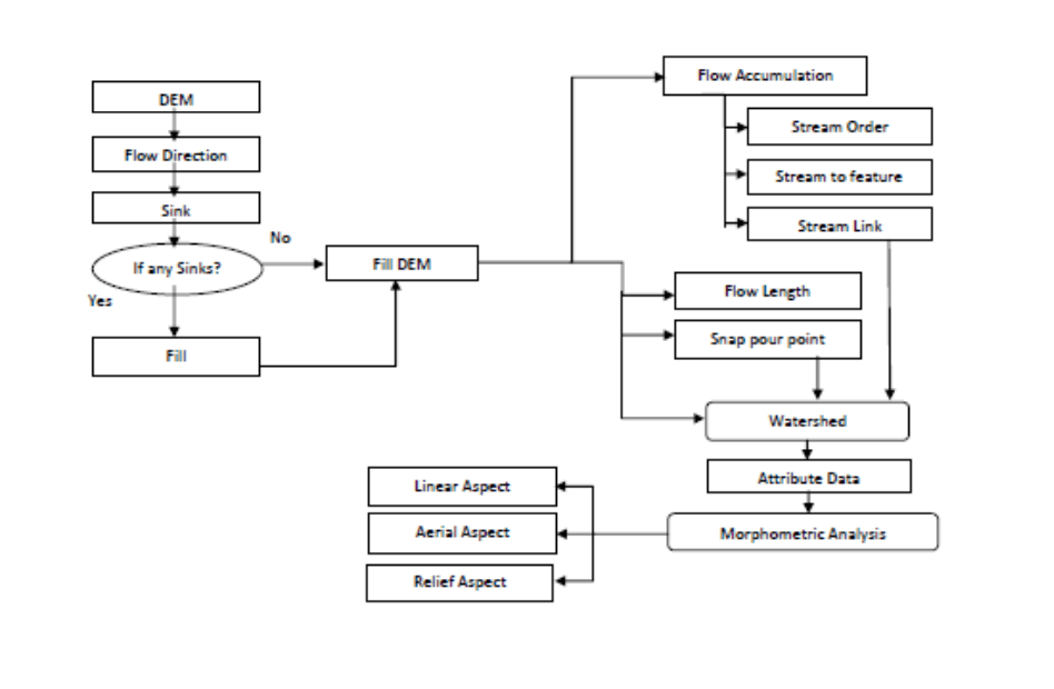
Manually physically extracting the drainage basin, network and assigning flow order from topographic maps and georeferenced satellite data for a large area is a time-consuming and laborious process.
Automatic extraction methods were applied using the EU-DEM model to estimate the drainage basin’s morphometric parameters such as areal, linear, and relief aspects using ArcGIS 10.5.1 software for raster and vector analysis. Raster analysis is based on complex algorithms and many other features that can be done with Hydrology tools in Spatial Analysis Tools. After raster data processing, vector tools were received to calculate some morphometric parameters. The method followed during this research is shown in the following flowchart model Figure 3.
4. RESULTS AND DISCUSSION
The quantitative morphometric analysis provides consistent information for assessing and understanding the hydrological characteristics of basins. Morphometric parameters of linear, surface, and relief aspects are discussed in detail in Table 1.
Tab. 1. Morphometric parameters of linear, surface, and relief aspects
| MORPHOMETRIC PARAMETERS | ||||
| DRAINAGE SYSTEM | Formula | Result | Unit | Refererence |
| Drainage Network | Hierarchical rank | Strahler (1952) | ||
| Stream order (Su) | GIS analysis | 57,42 | km | Strahler (1952) |
| Strahler I | GIS analysis | 23,69 | km | Strahler (1952) |
| Strahler II | GIS analysis | 20,16 | km | Strahler (1952) |
| Strahler III | 𝐿𝑢 = 𝐿1 + 𝐿2 +⋅⋅⋅+𝐿n | 101 | km | Strahler (1964) |
| Stream length (Lu) km | 𝑁𝑢 = 𝑁1 + 𝑁2 +⋅⋅⋅+Nu | 27 | Horton (1945) | |
| Stream number (Nu) | Lur =Lu/(Lu-1) | 0,85 | Strahler (1964) | |
| Stream length ratio (Lur) 2/3 order | Lur =Lu/(Lu-1) | 0,41 | Strahler (1964) | |
| Stream length ratio (Lur) 1/2 order | Rb= Nu/Nu+1 | 1,17 | Strahler (1964) | |
| Bifurcation ratio (Rb) II/III order | Rb= Nu/Nu+1 | 2,42 | Strahler (1964) | |
| Bifurcation ratio (Rb) I/III order | GIS analysis | 29,41 | km | |
| Main channel length (C1) | GIS analysis | 28,07 | km | |
| Minimum main channel distance (C2) | K= Cl/C0 | 1,04 | Horton (1945) | |
| BASIN GEOMETRY | ||||
| Basin Area (km2) (A) | GIS analysis | 311 | km2 | |
| Basin Perimeter (P) | GIS analysis | 619 | km | Schumm (1956) |
| Basin Length (Lb) (km) | GIS analysis | 35 | km | Schumm (1956) |
| Form ratio (Ff) | Ff = A / Lb2 | 0,25 | km | Horton (1932) |
| Elongation ratio (Re) | Re= 2√(A/π)/L | 0,86 | Schumm(1956) | |
| Texture ratio (Rt) | Rt=N1/P | 3,93 | Horton (1932) | |
| DRAINAGE TEXTURE (DT) | Dt=Nu/P | 0,05 | Horton (1932) | |
| Drainage density (Dd) | Dd=Lu/A | 0,32 | km/km2 | Horton (1932) |
| RELIEF CHARACTERIZATION | ||||
| Minimum Basin Height (z) (m) GIS software analysis | GIS analysis | 606 | m | |
| Maximum Basin Height (Z) (m) | GIS analysis | 2097 | m | |
| Total Basin relief (H) (m) | H = Z – z | 1491 | m | Strahler (1952) |
| Relief Ratio (Rhl) | H/Lb | 42,6 | m | Schumm (1956) |
| Average river slope | GIS analysis | 28 | % | |
| Average basin height | GIS analysis | 1309 | m | |
| Hypsometric integral (Hi) | Hi= Hsr-z/ Z-z | 0,47 | (Perez-Pena i dr., 2009 |
Linear aspects of the drainage system reveal watercourses’ characteristics and indicate the basin’s lithological and structural characteristics. The hierarchical order is the initial step in basin analysis. According to Strahler’s hierarchy, the first order’s length of watercourses is 57.42 km, of the second-order 23.69 km, of the third order, 20.16 km. The total length of all watercourses is 101 km. The bifurcation ratio, the coefficient of river flow development, and the stream length ratio show that the basin’s drainage is under the influence of tectonic geological structures.
Surface aspects show the two-dimensional properties of the drainage basin. The drainage basin has an irregular oval shape. The shape factor indicates that the pool is elongated. The drainage texture for this basin indicates the rough drainage texture. This basin is characterized by highly permeable limestone rocks, eruptive, and easily erodible alluvium. This mainly affects the resistance of rocks and soil to erosion and the ability to infiltrate.
The ratio of the amplitude of the relief in the basin to the basin’s length speaks of the basin’s incredible steepness, i.e., the tremendous potential erosion in the basin. The relief characteristics indicate an excellent water flowability and high runoff in the primary and secondary precipitation periods. The hypsometric integral indicates that the relief is in a mature phase.
5. CONCLUSION
In this research, quantitative morphometric estimates and analyses of linear, surface, and relief aspects of the drainage basin are presented. This paper contributed to the knowledge about the drainage basin of the river Gracanica and showed the possibility of using EU-DEM data and GIS techniques to assess morphometric parameters. The development of reliable DEM data and similar methods can play an essential role in planning and conducting hydrological activities.
REFERENCES
- Bashfield, A., and Keim, A. (2011). Continent-wide DEM Creation for the European Union. 34th International Symposium on Remote Sensing of Environment. The GEOSS Era: Towards Operational Environmental Monitoring. Sydney, Australia 10–15 April 2011.
- Burrough, P. A., & McDonnell, R. A. (1998). Principles of geographical information systems. New York, NY: Oxford University Press Inc.
- Chorley R.J., Schumm S.A., Sugden D.E. (1984). Geomorphology. Methuen, London
- Chorley, R.J., Schumm, S.A., & Sugden, D.E. (1984 ). Geomorfology (str. 605 ). London : Methuen & Co .
- Clarke, J. I. (1966). Morphometry from maps, Essays in geomorphology (pp. 235–274). New York, NY: Elsevier.
- Evans, I. S. (1984). Correlation structures and factor analysis in the investigation of data dimensionality: Statistical properties of the Wessex land surface, England. In: Proceedings of the Int. Symposium on Spatial Data Handling, Zurich. GeographischesInstitut (pp 98–116). Universitat Zurich-Irchel.
- Hengl, Tomislav & Reuter, Hannes. (2008). Geomorphometry. Concepts, Software, Applications.
- Horton, R. E. (1945). Erosional development of streams and their drainage basins: Hydro-physical approach to quantitative morphology. Geological Society of American Bulletin, 56, 275–370.
- Merritts, D., & Vincent, K. R. (1989). Geomorphic response of coastal streams to low, intermediate, and high rates of uplift, Mendocino junction region, northern California. Geological Society of American Bulletin, 101, 1373–1388.
- Mouratidis, A., Ampatzidis, D. (2019). European Digital Elevation Model Validation against Extensive Global Navigation Satellite Systems Data and Comparison with SRTM DEM and ASTER GDEM in Central Macedonia (Greece). ISPRS Int. J. Geo-Inf., 8, 108.
- Pareta, Kuldeep & Pareta, Upasana. (2011). Quantitative morphometric analysis of a watershed of Yamuna basin, India using ASTER (DEM) data and GIS. International Journal of Geomatics and Geosciences. 2.
- R. E. Horton. (1932). Drainage basin characteristics, Transactions of American Geophysics Union, vol. 13, pp. 350–361.
- Radojičić, B. (2005). Vode Crne Gore. INSTITUT ZA GEOGRAFIJU, Nikšić.
- Radojičić, B. (2008). Geografija Crne Gore – regije. DANU, Podgorica.
- Radojičić, B. (2010). Opština Nikšić – priroda i društveni razvoj. Filozofski fakultet, Nikšić.
- Resmi, M.R., Babeesh, C. & Hema, A. (2019). Quantitative analysis of the drainage and morphometric characteristics of the Palar River basin, Southern Peninsular India; using bAd calculator (bearing azimuth and drainage) and GIS, Geology, Ecology, and Landscapes, 3:4, 295-307, DOI: 10.1080/24749508.2018.1563750.
- Shreve, R.W. (1969) Stream lengths and basin areas in topologically random channel networks. J Geol 77:397–414.
- Šiljeg, A., Barada, M., & Marić, I. (2018). Digital Terrain Modelling. University of Zadar – Alfa d.d., Zagreb.
Remark:
The paper was published in:
